Summary
Staying Afloat: Uncovering the Flooding Crisis in Jamaica’s Most Affected Regions examines the persistent and escalating challenge of flooding in Jamaica, a nation highly vulnerable to extreme weather events and their associated impacts. Driven primarily by intense rainfall, tropical storms, hurricanes, and exacerbated by human activities such as deforestation, sand mining, and inadequate waste management, flooding poses a significant threat to the island’s environment, infrastructure, and socio-economic stability. This crisis is compounded by Jamaica’s varied topography and geological features that influence water drainage and flood risk, making certain regions, especially coastal and low-lying areas, particularly susceptible.
The flooding crisis in Jamaica is notable for its widespread human and economic consequences, including loss of life, displacement, damage to homes, critical infrastructure, and disruption to vital sectors such as tourism and agriculture. Severe weather events such as hurricanes Gilbert (1988) and Melissa underscore the ongoing vulnerability of the island to natural disasters intensified by climate change, which is expected to increase rainfall intensity and flood frequency in coming decades. Urbanization and environmental degradation further aggravate flooding impacts, overwhelming drainage systems and threatening communities located in flood plains and unstable terrains.
Governmental response efforts, led by the Office of Disaster Preparedness and Emergency Management (ODPEM), alongside community initiatives and international partnerships, have sought to improve flood preparedness, mitigation, and recovery. Despite these efforts, challenges persist due to resource limitations, incomplete hazard mapping, and coordination difficulties, which hinder comprehensive flood risk management across Jamaica. The ongoing reduction in international aid, particularly following the end of USAID’s disaster response programs, raises concerns about sustaining effective flood relief and resilience-building measures.
Looking forward, advances in flood risk modeling, hazard mapping, and community engagement provide important tools for developing adaptive strategies to confront Jamaica’s flooding crisis. Regulatory reforms, infrastructure upgrades, and localized flood resilience programs are crucial to mitigate future impacts, particularly as climate change threatens to intensify extreme weather events. This article explores the causes, impacts, and responses to Jamaica’s flooding crisis, emphasizing the urgent need for coordinated, well-resourced, and climate-resilient approaches to safeguard the nation’s most vulnerable regions.
Background
Flooding in Jamaica is primarily driven by a combination of intense rainfall, the island’s topography, and its lithology. Most flood events tend to occur during the peak rainfall months of May and September to October, with hurricanes and tropical storms contributing to approximately 43% of devastating floods on the island. Severe weather phenomena, such as tropical depressions and hurricanes, often produce heavy rainfall that leads to widespread flooding, particularly in vulnerable regions.
Historically, Jamaica has experienced significant flooding and damage caused by extreme weather events. For instance, Hurricane Gilbert in 1988 made landfall on the island as a Category 4 hurricane with winds of 130 mph before strengthening to Category 5 when it struck Mexico’s Yucatán Peninsula. The storm caused 319 deaths, with most fatalities resulting from flooding in Mexico; however, Jamaica also suffered extensive impacts from flooding and wind damage during this event. Similarly, more recent storms such as Hurricane Melissa have underscored the ongoing threat posed by hurricanes to Jamaica’s infrastructure and communities.
The island’s diverse topography, including limestone-dominated areas and mountainous regions such as the Nassau Mountains, influences flood risk patterns. Flood-prone zones are often located in low-lying areas and regions with specific geological features that affect water drainage. Efforts to mitigate flooding include the management of gullies and ravines designed to channel water back into natural systems, although heavy rainfall can still overwhelm these measures.
In developing regions of Jamaica, data scarcity has historically hindered accurate flood risk assessments. Recent advancements in flood risk modeling use digital elevation models and historical flooding data to identify hotspots and project future flood scenarios under climate change. These approaches are crucial for planning and implementing mitigation strategies in vulnerable communities. The combination of updated flood records and projections of increasing rainfall intensity—expected to rise by 27% to 59% by 2100 for extreme events—highlight the urgent need for adaptive flood management in Jamaica.
Causes of the Flooding Crisis
Flooding in Jamaica is primarily caused by severe weather conditions such as intense rainfall associated with tropical depressions, hurricanes, and tropical cyclones. These weather events generate heavy precipitation that overwhelms drainage channels, rivers, and streams, resulting in water spilling over their banks and flooding the surrounding areas. Flash floods, a common type of flooding in Jamaica, often occur when heavy rain or cloudbursts impact small drainage basins, leading to sudden and severe inundation.
In addition to natural weather phenomena, human activities significantly exacerbate the risk and severity of flooding. Environmental degradation through sand mining, deforestation, and poor garbage disposal disrupts natural water flow and drainage systems, increasing vulnerability to flood events. Urban development has further intensified flooding by reducing soil infiltration capacity due to the proliferation of impervious surfaces such as roads, buildings, and parking lots. This increase in surface runoff overwhelms the already inadequate drainage infrastructure, particularly in urban centers. Unplanned settlements in flood plains and on unstable slopes compound the risk by placing communities directly in harm’s way and often lacking proper flood defenses.
Furthermore, pollution and waste management challenges worsen flooding impacts. Large volumes of waste are frequently dumped in gullies and rivers, clogging waterways and exacerbating flood hazards while also polluting marine environments. This environmental strain is heightened by the growing per capita waste generation, which is expected to rise alongside population growth and changing consumption patterns.
Climate change also plays a critical role in the flooding crisis by intensifying storm events and increasing rainfall intensity. While the frequency of hurricanes may not rise significantly, warmer ocean temperatures contribute to stronger storms with greater rainfall, increasing the likelihood of severe floods. Sea-level rise is projected to further exacerbate flooding risks, particularly in coastal areas such as Kingston, where significant portions of the city could become permanently submerged without adequate shoreline defenses by the end of the century under worst-case scenarios.
Impact of Flooding
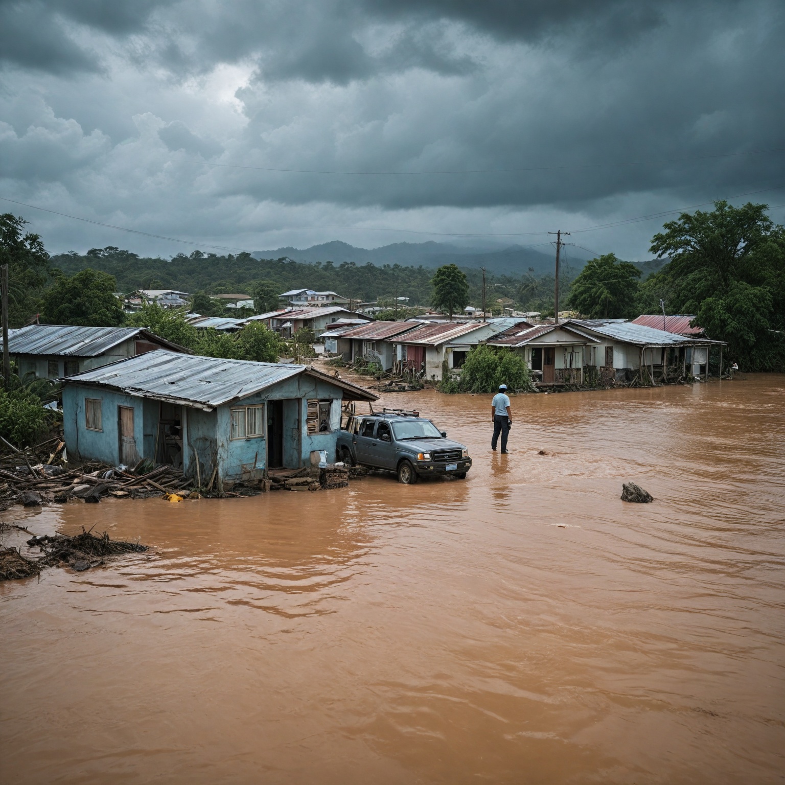
Flooding is the most common natural hazard in Jamaica that causes significant loss of life, widespread damage to infrastructure, disruption to economic activities, and human suffering. The effects of floods extend beyond immediate physical destruction to include forced evacuations, displacement of vulnerable populations, and long-term setbacks to national development. Floodwaters damage buildings, roads, agricultural crops, and critical infrastructure, thereby undermining the country’s security and economic stability.
Severe weather events such as tropical depressions, hurricanes, and intense rainfall often trigger floods across Jamaica’s low-lying and flood-prone areas, including closed limestone valleys like Newmarket, where water tends to pond due to poor drainage. Flash floods resulting from sudden cloudbursts and riverine floods from heavy rainfall over river basins are among the most common flooding types, each causing different levels of damage depending on the affected region.
The economic impact of flooding is profound. Damage to tourism infrastructure, one of Jamaica’s most important economic sectors, has been documented in multiple flood events, including those in Montego Bay which caused hotel flooding and blocked access routes, thereby preventing workers from reaching their jobs. Additionally, major storms and floods have caused disruption to commerce and agriculture, compounding the losses beyond the immediate physical damage. For example, insured losses following severe wind and flood events are predominantly linked to commercial properties such as hotels, resorts, and high-rise buildings, often including significant business interruption costs. The total value of social and economic assets exposed to flood hazards in Jamaica is estimated at approximately US$18.6 billion, highlighting the scale of potential damage and vulnerability.
Flooding also poses serious public health concerns. Contaminated floodwaters threaten access to safe drinking water, increasing the risk of waterborne diseases. Emergency management agencies emphasize the importance of treating water after floods and ensuring access to shelter, food, and medical care for displaced populations. Evacuations, though necessary to protect lives, often displace residents to temporary shelters in schools and churches, where personal belongings remain unprotected, causing emotional and social distress.
Furthermore, the increasing frequency and intensity of floods, driven by climate change and exacerbated by poor urban planning and environmental degradation, threaten to worsen economic vulnerabilities and hinder sustainable growth. Without adequate shoreline defenses and improved drainage infrastructure, projections indicate that parts of Kingston and other coastal areas may face permanent inundation by the end of the century. These ongoing challenges underscore the critical need for climate-resilient infrastructure and robust disaster risk reduction strategies to mitigate the long-term impacts of flooding on Jamaica’s most affected regions.
Most Affected Regions
Jamaica is one of the most vulnerable countries globally to natural hazards, particularly flooding, with coastal areas bearing the brunt of the risk. Approximately 96.3 percent of the nation’s GDP is exposed to two or more hazards, primarily along the coastlines where most of the capital towns are located. Among the parishes, St. James stands out as one of the most affected regions. This suburban parish, situated on the north-western end of the island, includes Montego Bay, the second-largest city in Jamaica. The parish covers an area of 594.9 km², with a population of around 184,662 as of 2012. Its terrain is predominantly limestone, and it features the Nassau Mountains running diagonally across it, contributing to varied flood risk zones.
Within St. James and its neighboring parishes such as Hanover and Westmoreland, flooding has been severe. Communities including Bucks Common, Denbigh, Nineteen Miles, Palmer’s Cross, Sandy Bay, Milk River, Swansea, and Bucknor have experienced significant flood damage. The Montego River, originating in central St. James, is a notable contributor to flood events in the area. During major storm events, such as the Category 5 storm that devastated western Jamaica, small communities like New River faced widespread inundation, with numerous fatalities and massive clean-up efforts reported.
Other vulnerable areas include lower sections of closed limestone valleys, such as Newmarket, where residents are particularly susceptible to flooding due to both natural topography and human activities like sand mining, deforestation, and improper waste disposal that exacerbate flood risk. Flooding is not only common but widespread throughout the Caribbean, affecting nearly 90% of countries in the region, and Jamaica consistently experiences high levels of damage from such events.
Beyond St. James, parishes like Clarendon, St. Catherine, and St. Thomas also face serious flooding issues. Clarendon, for example, has seen evacuations and the establishment of multiple shelters for displaced residents following severe flood events. Landslides have also been reported in St. Thomas, further complicating the disaster response. These patterns underscore the ongoing challenges in managing flood risk across Jamaica’s most vulnerable and densely populated regions.
Government and Community Response
The Government of Jamaica plays a central role in managing disaster response and flood mitigation through the Office of Disaster Preparedness and Emergency Management (ODPEM). Established in the wake of the devastating June 1979 floods, ODPEM operates as the statutory national disaster management organization, tasked with coordinating emergency response, reducing disaster impacts, and promoting preparedness across the island. The agency functions under the Ministry of Local Government and Community Development and is overseen by a Board of Management. ODPEM’s mandate includes developing policies and programs aimed at maintaining a state of national readiness, supporting mitigation measures at parish and community levels, and collaborating with local government authorities and voluntary organizations to build resilience against natural hazards.
In recent years, ODPEM has made progress in implementing international frameworks such as the Hyogo Framework for Action, although challenges persist due to limited financial resources and political will. Complementing these efforts, the Water Resources Authority has produced flood hazard maps for key river systems, including the Rio Cobre and Rio Grande, which feed into decision-support tools used by policymakers to enhance flood mitigation strategies and evacuation planning.
Community involvement is a critical aspect of flood response. Residents in flood-prone areas are regularly urged to remain vigilant and prepared, especially those living in vulnerable zones. However, the decision to evacuate can be difficult due to concerns about property and possessions left behind, underscoring the importance of sensitive communication and support during evacuation processes. Public health concerns following flooding focus on ensuring access to clean drinking water, food, shelter, and medical care, with advisories emphasizing the treatment of water to prevent illness from contamination.
On the grassroots level, several community-led initiatives have emerged to bolster flood resilience. For example, the Jamaica Bay Community Flood Fellowship Program, launched in 2024 with funding from NOAA and FEMA, connects leaders from flood-affected neighborhoods to share knowledge and develop local solutions. Participants, including local administrators and community advocates, work to apply practical preparedness strategies tailored to their neighborhoods and families.
Non-governmental organizations also contribute significantly to disaster relief and recovery efforts. American-based groups such as the American Friends of Jamaica (AFJ) collect donations and support local partners in restoring infrastructure and empowering communities across multiple parishes. Meanwhile, international humanitarian organizations like World Vision and World Central Kitchen provide emergency supplies, food, hygiene kits, and shelter materials to families affected by flooding events such as those caused by Hurricane Melissa.
Despite the end of the USAID-led disaster response efforts, which has raised concerns about the continuity and effectiveness of U.S. assistance, the combined efforts of government agencies, community organizations, and international partners continue to form the backbone of Jamaica’s flood response and recovery operations. Together, these actors strive to reduce the socio-economic disruptions caused by flooding, protect vulnerable populations, and foster long-term resilience in the most affected regions.
Flood Mitigation and Long-Term Strategies
Flood mitigation in Jamaica involves a multi-faceted approach that combines accurate risk assessment, community engagement, infrastructure improvements, and policy development to address the increasing challenges posed by severe weather events and climate change. Given the island’s vulnerability to flooding—exacerbated by poor drainage systems, urbanization, and environmental degradation such as deforestation and sand mining—effective mitigation measures are critical for reducing damage and protecting vulnerable populations.
A key component of flood mitigation is the use of advanced topographic and hydrological data to identify flooding risk hotspots. Digital elevation models, combined with historical and calculated flood extents, allow for accurate mapping of flood-prone areas even in data-sparse regions. This information supports damage assessments and informs planning and emergency preparedness efforts. These data outputs feed into map-based decision-making tools designed to assist policymakers in developing or revising flood mitigation strategies, evacuation plans, and national disaster risk management frameworks. Such tools also guide community adaptation measures to enhance resilience and protect those most vulnerable to flooding impacts.
Local and national organizations play an essential role in flood risk management by providing supplemental information and expertise. Coordination with meteorological agencies, engineering associations, and local councils ensures that mitigation strategies are grounded in best practices and emerging knowledge. Furthermore, adherence to codes such as the International Property Maintenance Code (IPMC) throughout project design and construction phases helps balance mitigation costs with long-term savings from reduced flood damage and repair expenses.
Policy and regulatory frameworks are vital for sustainable flood risk reduction. Current Jamaican planning regulations include setback requirements from the mean water line, although these are often based on foreshore slope rather than actual risk data. There is a recognized need to generate comprehensive storm surge data and develop detailed hazard mapping at appropriate scales to establish effective setback distances and integrate engineering considerations such as flood-proofing. Design criteria adopted by the Jamaica Institution of Engineers provide guidance for wind loading, earthquake resistance, and flood levels in drainage infrastructure, which are essential for resilient construction and infrastructure development.
Community-driven initiatives also contribute significantly to long-term flood resilience. Programs like the Jamaica Bay Community Flood Fellowship connect local leaders from flood-prone neighborhoods to build knowledge, share tools, and develop localized solutions. These efforts emphasize empowerment, practical preparedness, and collaboration among academia, government, and community organizations to foster resilience and improve health and safety outcomes. Additionally, support from local partner organizations helps restore critical infrastructure and living conditions in affected parishes, promoting recovery that strengthens communities against future flood events.
Challenges in Addressing the Crisis
Addressing the flooding crisis in Jamaica faces numerous challenges that hinder effective disaster risk management and mitigation efforts. One major obstacle is the ongoing environmental degradation caused by human activities such as sand mining, deforestation, and poor waste disposal. These activities increase the vulnerability of affected areas by exacerbating flood risks and causing damage to critical infrastructure including roads and buildings, which in turn undermines national security and development. Residents living near flood-prone zones remain highly vulnerable and require constant alertness due to these compounded risks.
Institutionally, while Jamaica has made progress through the establishment of the Office of Disaster Preparedness and Emergency Management (ODPEM) and its implementation of frameworks like the Hyogo Framework, limitations persist. The lack of adequate financial resources and sometimes insufficient political will have constrained the full realization of disaster risk reduction strategies. Furthermore, efforts such as flood hazard mapping by the Water Resources Authority remain limited to select river basins, impeding comprehensive nationwide planning.
International cooperation and relief efforts have also faced setbacks. The dismantling of key agencies like USAID, previously a leading partner in disaster response, has raised concerns about the effectiveness and sustainability of hurricane relief initiatives in Jamaica. Meanwhile, non-governmental organizations and diaspora groups continue to mobilize funds and support through platforms that emphasize local empowerment and efficient allocation of resources to emergency relief, housing, healthcare, and economic recovery.
Additional challenges stem from geographic and climatic factors. The island’s diverse topography, combined with insufficient data in certain regions, complicates accurate flood risk assessment and damage estimation. Innovative methods using digital elevation models and historical flood data have been developed to address these data gaps, but broader application and resource allocation remain essential. Climate change further intensifies inland flooding risks, placing vulnerable communities under growing threat and necessitating adaptive measures that are still in early stages of implementation.
Finally, urban expansion and inadequate drainage infrastructure present significant hurdles. The 2018 Beating Plastic Pollution Campaign highlights the environmental pressures from pollution that clog waterways, exacerbating flood impacts on coastal ecosystems, tourism, infrastructure, and livelihoods. Without robust urban planning and climate-resilient infrastructure investments, economic vulnerabilities will worsen, potentially impeding Jamaica’s sustainable growth prospects. These multifaceted challenges illustrate the complexity of addressing the flooding crisis and underscore the need for coordinated, well-resourced, and forward-looking responses.
Future Outlook
Projections indicate a significant increase in extreme rainfall intensities in Jamaica by the year 2100, with anticipated rises ranging from 27% to 59% for events with a 100-year return period. This increase is primarily driven by greater variability in precipitation patterns associated with climate change. To address these evolving risks, ongoing projects are employing historical flood data and climate projections to develop detailed flood inundation maps for five, ten, and twenty-five-year return periods. These maps aim to enhance understanding of future flood risk and inform adaptation strategies for vulnerable communities.
In addition to mapping efforts, regulatory frameworks are being developed to guide coastal setback regulations based on statistical storm surge risk assessments. Such regulations rely on high-resolution planimetric and topographic data to demarcate flood lines and integrate engineering considerations such as flood-proofing and emergency planning. Legal instruments like Development Orders are proposed to enforce these setback measures consistently across Jamaica’s shoreline. The incorporation of accurate topographic data remains a critical challenge, particularly in remote areas with limited resources, but is essential for effective flood risk mitigation planning.
Mitigation strategies emphasize balancing upfront costs with long-term savings through reduced damage and repair needs. These strategies are integrated throughout project design and construction phases to enhance resilience against cyclones and other weather events. Outputs from these initiatives feed into decision-support tools that assist policymakers in revising flood mitigation measures, evacuation protocols, and disaster risk management plans. These tools also guide community-level adaptation measures, aiming to protect the most vulnerable populations amid increasing flood risks.
Community engagement plays a crucial role in building flood resilience. Local leaders and stakeholders, including district administrators and parents, are actively involved in promoting preparedness strategies and supporting sustainable, community-led efforts. These initiatives foster long-term resilience and ensure that adaptation measures are contextually relevant and socially inclusive. Specifically, in urban centers like Montego Bay, addressing challenges such as unplanned urban sprawl, enforcement of building codes, and maintaining effective drainage systems requires meaningful participation from local communities and businesses to enhance governance and flood management outcomes.
Case Studies
The UN Global Assessment Report on Disaster Risk Reduction (GAR 2024) presents ten detailed case studies that employ forensic risk analysis to systematically investigate the causes, impacts, and mitigation effectiveness of various disasters in Jamaica. One notable case occurred on January 8, 2021, when heavy rains caused severe flooding in Montego Bay, leading to inundated roads and damage to vehicles and buildings across the city. Montego Bay, situated in Saint James Parish, is a critical commercial and tourist hub divided into a northern tourist area along the shoreline and commercial-industrial zones inland. The city’s vulnerability to flooding is heightened by its geography and the presence of two main rivers, Saint James and another unnamed river flowing north then west into Montego Bay.
Other regions in Jamaica have also experienced significant flood-related disasters. For example, in April 2017, flooding heavily affected Clarendon Parish and surrounding areas, including St Catherine and St Thomas, causing widespread displacement. Multiple neighbourhoods such as Bucks Common, Denbigh, Palmer’s Cross, and Swansea were among the worst hit. Evacuations were necessary, and four shelters were opened in Clarendon to accommodate those displaced by the floods. The flooding also triggered several landslides, particularly in St Thomas, compounding the damage and risk to residents.
These case studies highlight the complex interplay of natural and anthropogenic factors contributing to flooding risk. Human activities such as sand mining, deforestation, and poor garbage disposal have exacerbated environmental degradation, increasing vulnerability to floods and their impacts on infrastructure and community safety. The disruption caused by these floods affects not only physical structures but also personal, economic, and social activities, underscoring the critical need for improved risk management and preparedness in Jamaica’s most affected regions.
Efforts to address flood risk in Jamaica include the development of analytical tools and policy reviews. For instance, flood risk modeling tools specific to Jamaica have been developed as part of broader Caribbean hazard assessments, aiming to better integrate multi-hazard risk factors into comprehensive disaster management strategies. Furthermore, existing policy frameworks, such as those advocated by the Jamaica Institution of Engineers, establish design criteria for building resilience against wind, earthquake, and flood hazards, using defined return periods for hazard events to guide infrastructure planning and mitigation.
Collectively, these case studies emphasize the urgency of understanding flood dynamics within Jamaica’s varied geographic and socio-economic contexts to inform effective adaptation and response measures that protect vulnerable communities across the island.
The content is provided by Blake Sterling, Home Upgrade News